In the very beginning, no one wanted the Bloomingdale Line. When the original freight right-of-way was constructed in 1873 on top of the old Bloomingdale Road, blazing an industrial link between Milwaukee and Chicago, residents of the 15th ward rallied to fight it. They protested that the railroad would cause “great damage” to surrounding property, not to mention how it would “obstruct” schools and churches in the area. Some even sued in an attempt to stop construction.
Those civic-minded Chicagoans of past centuries might be amused to see the open-armed embrace given to the Bloomingdale Trail today. The elevated tracks, fallow since the late 20th century, are becoming a 2.7-mile-long green byway for bikers and pedestrians. The 606, as it was renamed in 2013 (after the first three digits of all Chicago zip codes), has been cause for intercommunity cooperation and robust public and private support. Rather than creating “great damage,” property values surrounding the 606 are soaring. Rather than obstructing access to community amenities, the track puts five parks, 25 schools, two existing light rail stations, a suburban commuter rail stop, and a host of bus arteries within a 10-minute walk.

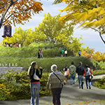
More than a 2.7-mile elevated bike path, the 606 will create six new neighborhood parks at various access points on Chicago’s northwest side. The former rail line has been unused since 2001.


DETAILS
Location Chicago
Previous Use Railroad viaduct
Status Under construction, expected opening 2015
Length 2.7 miles
Owner The Trust for Public Land
Advocate Friends of the Bloomingdale Trail
This former east-west rail line is intended to remain a transportation corridor, with 10 feet of the 14-foot-wide path dedicated to shared bike lanes. Along its nearly three miles, the 15-foot elevation makes gradual rises and dips, with entrances integrating with the adjacent neighborhood streets, creating as many ADA-compliant points of entry as possible.
Just as they did in 1873, Chicago’s Northwest Side residents made their voices heard. But unlike in the past, community input became a central part of the plan. During meetings, locals whose homes bordered the trail spoke up. “Some residents were very vocal in demanding privacy from the trail,” says Carol Ross Barney, whose eponymous firm was on the Phase I design team that presented an initial framework for the trail in mid-2013. The design response to these requests was twofold. First, public art and landscaping create experiences that keep interest on the trail. Secondly, the thoroughfare is in places “vertically or horizontally separated from adjacent buildings,” Ross Barney says, “giving what otherwise could have been a straight path some variation.”


The park is already a story of reusing outdated infrastructure, but other parts of historic Chicago were grafted in as well. Perhaps the most visible example of this is a 100-year-old bridge that once spanned Ashland Avenue. The old, 70-foot-long structure was removed, cleaned, and repaired, then trundled on a flatbed over to Western Avenue to serve as a section of the 606. It was a sight to behold on the narrow neighborhood streets, spanning the road and moving so slowly that the hard-hatted construction workers just ambled alongside. If it hadn’t been for the traffic backing up behind, it could have been mistaken for some sort of community parade, celebrating, for the first time, the construction of the Bloomingdale Trail.
Click through the other four linear parks below.


