
As the fourth largest city in North America, Toronto has its share of post-industrial landscapes to contend with. And as the largest metropolitan hub on the Great Lakes, Toronto’s share of derelict industrial land is heavily clustered on its Lake Ontario waterfront. To reclaim this land, a major revitalization effort has been underway for the past decade, resulting in a string of reimagined neighborhoods, parks, and mixed-use districts that are slowly filling the city’s interstitial spaces. The latest addition to the city’s emerging urban-environmental fabric is an 18-acre park near the mouth of the highly channelized Don River, the waterway responsible for what was historically an immense estuary that was filled in as the city grew, eventually becoming Toronto’s industrial port lands.
Known as Corktown Common—after one of the adjacent neighborhoods partially destroyed to make way for the railway—the park may well represent the most complex feat of hydrologic engineering of any site along Toronto’s new “blue edge” thus far. And yet the park design by Michael Van Valkenburgh Associates (MVVA) builds upon the work that was done to reshape the river corridor into a more naturalized analog of the landscape that was buried under pavement long ago, leaving an ecologically functional, aesthetically pleasurable park in its place.
PROJECT
LOCATION Toronto, Ontario
Size 18 acres
Completion 2013 (Phase 1), 2015 (Phase 2)
Program Urban public park and flood protection
Awards Federation of Canadian Municipalities 2014 Sustainable Communities Award
TEAM
LANDSCAPE ARCHITECT Michael Van Valkenburgh Associates
Client Waterfront Toronto
Architect Maryann Thompson Architects (park pavilion)
Civil/Structural/MEP Engineer Arup Irrigation Creative Irrigation
Horticulture Consultant Great Ecology
Horticultural Soil Scientist Pine and Swallow Environmental
Environmental Scientist Golder Associates
General Contractor Eastern Construction
Landscape Contractor Aldershot Landscape Company
SUPPLIERS
Woody Plants Braun Nursery, Connons Nusery, Sheridan Nursery
Herbaceous Plants Acorus Restoration
Water Play Equipment Water Odessy
Play Equipment Henderson Recreation
Remediation of the brownfield site was only the first of the project’s many challenges. The environmental pollution together with the area’s vulnerability to flooding had long ago left the area as an abandoned wasteland, though by virtue of its proximity to the downtown core—a fifteen-minute walk away—it would otherwise have been considered prime real estate. “The more that Toronto developed areas of impervious surfaces upstream, the greater the volume of stormwater that was directed into the channelized Don River,” says Emily Mueller De Celis, MVVA’s project manager for Corktown Common. “It was an increasingly fragile condition.” Until very recently, since the 1950s, moderate to severe flooding in the lower Don River Valley had become a fact of life.
HELPING A BUILDING BOOM
After languishing for years as one redevelopment proposal after another was nixed due to either a lack of public support or fiscal viability, Waterfront Toronto, the agency charged with redeveloping the area known as the West Don Lands, formed a partnership with the Toronto Region Conservation Authority and Infrastructure Ontario to implement strategies that would allow for maximum urban development and maximum green space while simultaneously addressing the flooding and contamination issues.
If that sounds like a tall order, it was—one that took six years and a veritable mountain of imported fill to accomplish. The polluted ground was capped, and the underlying loose, wet, organic fill was dewatered with the weight of more than 400,000 yards of clean fill piled on top. In the process, to help mitigate the flooding, the elevation of the site was raised 12 feet (in some places the final topography was raised as much as 30 feet).
The result is not at all the classic floodplain levee, but a piece of green infrastructure that serves a variety of functions, including the elimination of the neighborhood’s floodplain designation, which allowed it to be redeveloped after four decades of obsolescence.
“This is not just a piece of stormwater infrastructure, but a piece of development infrastructure,” Mueller De Celis says. “Corktown Common may not be at the center of the development physically, but it is psychologically.” Since the first phase of the flood protection landform (FPL), as it’s called, was installed in 2010, development activity has been intense, with a significant portion of the 6,000 residences planned for the area either completed or under construction.

The 18-acre park was built up with imported fill in order to raise the area out of the flood plain. “This is not just a piece of stormwater infrastructure, but a piece of development infrastructure,” says MVVA’s Emily Mueller De Celis.

A series of stepped wetland basins, forming a sort of urban marsh, raises awareness of the West Don Lands’ location at the mouth of a former estuary.
The FPL protects not only the 80-acre West Don Lands redevelopment area, but also remedies long-standing flooding issues in a 500-acre swath of downtown. In potentially catastrophic storm events, the new park’s gently tapering riverside slope will fill with water in what Mueller De Celis calls a “flood release valve” intended to spare the adjacent areas from being submerged. To ensure the integrity of the FPL, no woody plant material or active recreation features could be sited in this half of the park. However, MVVA devised an ecologically diverse urban prairie with a meandering trail system that allows residents to enjoy an unexpected immersion in nature within the confines of the enormous city. This part of the park also serves as a crucial junction between the north-south Don Valley bike path and the network of east-west paths parallel to the waterfront.
“This park is a major player in the larger ecosystem,” Mueller De Celis says of the site’s location at the juncture between the Don River Valley and Lake Ontario. Birds and amphibians reportedly began to arrive spontaneously almost as soon as the wetlands were filled and planted. Wildlife habitat like this is important in any city, but in Toronto, the influence of the avian kind is writ large in ecological terms. The Greater Toronto Area is at the confluence of two major migratory flyways, meaning the estuary of the Don River was once a bustling pit stop for tired, hungry birds after completing their flight across Lake Ontario. Now, there is a bright new patch of green to guide them down to a safe place to rest.

Greywater from the splash pad is channeled alongside runoff to an underground cistern that supplies irrigation. The unique capture system collects every drop of water that falls on the park grounds.
EVERY DROP REUSED
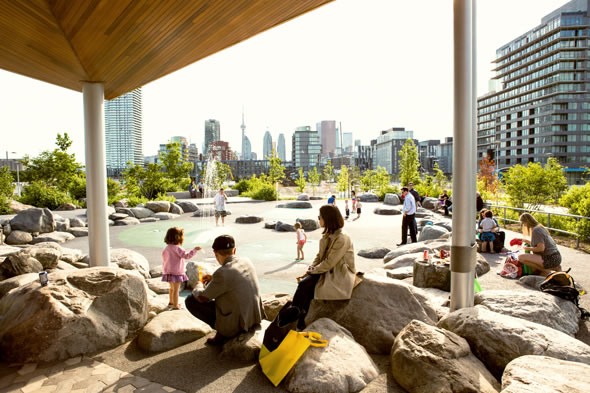
The program of the park’s 18 acres includes a splash pad, some of MVVA’s signature creativity-stimulating play equipment, a multiuse pavilion by Maryann Thompson Architects, more than 700 native trees, and all the open, unstructured space you would expect in a major urban park. But beneath the surface, there are other features that parallel the park’s larger purpose as a piece of urban infrastructure. Due to the engineering constraints of the FPL and its compacted clay core below, “we had to approach the site like we were on hard pan or on top of a building,” Mueller De Celis says. “So we designed a site-specific water-harvesting system that collects, filters, and reuses the stormwater and potable water from the water play area to create a working landscape. Every drop of water on the site is reused multiple times.”
Like children playing in a sandbox, it’s easy to imagine how much the design team must have enjoyed sculpting the massive hill of fill into a beautiful rolling park space, where every drop of surface flow is artfully steered into an innovative closed-loop water system. As Michael Van Valkenburgh tells it, “In the schematic design phase of the project, the dimensions of the central valley space were tested by laying it out with flags and string in a park in New York City so we could be sure that it felt the way we imagined it should.”
To bring awareness of the neighborhood’s location at the mouth of a former estuary, the landscape architects developed a two-acre series of stepped wetland basins that greets visitors at the main entrance. The forested hill that rises behind them sends its stormwater runoff directly to the constructed wetlands, along with the greywater from the splash pads at the other end of the park. Overflow from the wetlands is piped to a cistern buried under the large field at the center of the park, which in turn supplies the park’s irrigation system. Other than the area adjacent to the wetlands, any water that filters through the park’s topsoil finds its way back to the underground cistern through a network of perforated pipes—and then the cycle begins again.
While the stormwater collection system works hard to conserve resources, MVVA’s managing principal Laura Solano says that sustainable landscapes have another function: “[They] can also heighten visitors’ experiences by revealing the dynamic and complex systems that make up the natural world,” she says. “One of our goals was to make something interesting happen at the intersection of landscape performance and user experience.”

In addition to 700 new, native trees, Corktown Common features play equipment designed to stimulate creativity.