
This article is an excerpt from New Orleans: Structure, Community, City. Find it at the Greenbuild Bookstore or contact Jen Illescas at jen@www.devlf.com/magazine.
–
New Orleans is a complex place. It’s a city of people and history, celebrations and sorrows, gorgeous architecture and urban decay—and more recently, devastation and a determined resurgence.
At the center of this is water, which acts as both friend—indeed, water is the reason this city exists—and as foe. Probe the hydrology of New Orleans and you’ll discover that water comes by river, by rain, by storm surge, and through the ground. At least, that is how nature intended. Current events show that nature, when thwarted, can wreak disaster.
History also tells us that cities hit by disaster often rise again. Chicago had its 1871 fire and came back with a revered urban plan fit for the 20th century. San Francisco was brought to its knees by the earthquake of 1906 and today is the center of the digital universe. In each case, measures were taken to either prevent or mitigate the same disasters from recurring; but of course, that requires an understanding of the root causes and threats those cities inevitably face.

New Orleans’ Urban Water Plan references the use of parks as stormwater retention spaces after heavy rainfall.
One mistaken perception of New Orleans has been that the floodwaters from Hurricane Katrina were the city’s sole catastrophe. They weren’t. While water in all the wrong places at all the wrong times was indeed a huge problem and caused the deaths of more than 1,800 people, it was not the Crescent City’s only problem with water—not by a long shot.
Ironically, one of the biggest problems in New Orleans is dry soil. And what led to this curious fact were well-intentioned, but under-informed, efforts to get water out of the city at all times as a fundamental strategy over the better part of the 20th century. This was based on the notion that the city’s frequent hurricanes and its 60 inches of rain per annum were forces to resist.
The enacted solution was to pump the water out, all of the time, because water was the enemy—because it often was, even more so when development began in low-lying areas after implementing the pumping system. Such trust the city fathers had in those pumps.

The Urban Water Plan was based on the concept that water is an asset for the city and should be used as an infrastructure network for stormwater as well as space for recreation. The city’s “layers,” which inform the plan, are illustrated below. Image: Palmbout Urban Landscapes

Image: Waggonner & Ball
This idea of controlling water was not unique to New Orleans; in the 20th century, Chicago reversed the flow of its urban river, the Colorado River was tamed by the Hoover Dam, and the Central Valley Project in California rerouted three rivers to transform a desert into farmland. The Netherlands has pushed back the sea with windmills since the 1200s.
Most of these water projects have performed as intended; the Hoover Dam provides electricity to cities in Nevada, Arizona, and California, enabling growth. Every grocery store in America today carries produce originating in the vast agricultural regions of central California, and in Holland, great swaths of farmland exist solely because the Dutch were able to wrest land from the shallows of the North Sea.
But each of these altered the course of nature, and all are worthy of reexamination in an era of environmental awareness and climate change. We now have evidence of how tampering with natural systems can lead to significant problems and inconveniences, including deadly disasters. Call it the law of unintended consequences.

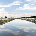
The Urban Water Plan proposes turning New Orleans’ many canals into functional, accessible waterfront parks. Image: Waggonner & Ball

Each canal offers opportunities for new green infrastructure and recreation for a total of 26 linear miles of waterfront space. Image: Waggonner & Ball
Fortunately, post-Katrina, New Orleans has responded. With the input of engineers and planners from the Royal Netherlands Embassy, the American Planning Association, the US Department of Housing and Urban Development, city leaders, regional economic development organization Greater New Orleans, Inc., New Orleans architecture and planning firm Waggonner & Ball Architects, and Senator Mary Landrieu, the Urban Water Plan (UWP or Plan) has been devised.
The UWP is hugely ambitious, disruptive, and transformative. Waggonner & Ball’s David Waggonner, a chief architect of the UWP, quotes Daniel Burnham, the architect who in 1909 coauthored the influential Chicago overhaul project series known as the Burnham Plan, in describing it: “Make no little plans.”
The Plan will revolutionize how water is treated in the city. Instead of walling off the canals to keep water out, which is the present scenario, the Plan will turn the canals into “blueways,” centers of recreation with appropriate space for overflow in heavy rains. Parks will have ample space for play when the city is dry and then double as detention ponds when it rains, protecting surrounding homes from flooding. The many facets all come down to treating water as an asset to embrace—one that will ultimately transform the city physically and financially.
It may cost $6.2 billion to implement, with no funding secured as yet; coastal wetland rebuilding already has a $50 billion price tag in a project called Coast 2050, funded by oil and gas royalties. The UWP will transform the city’s landscape, opening up and adding waterways and greenways where streets and homes, walled-off canals, and city rights-of-way now stand. It is subject to review, scrutiny, debate, and inevitable funding battles. But the Plan can transform the city in ways the rest of the world will one day imitate.

In the Upper Ninth Ward, train tracks kept New Orleanians from seeing and interacting with the Mississippi River. Now, the rustic Piety Bridge transports people from what feels like a transit wasteland on one side to an urban paradise overlooking the river on the other. Photo: Timothy Hursley

Designed by Hargreaves Associates, Crescent Park is a 1.4-mile-long, 20-acre riverfront oasis, replete with bioswales and native flora. From the remnants of the old Piety wharf building, park visitors look out to the city’s skyline—a physical reminder of New Orleans history and future. Photo: Timothy Hursley

Crescent Park reconnects residents of New Orleans with the Mississippi River by providing park space. Image: Hargreaves Associates
Unfortunately for New Orleans, the law of unintended consequences came into force almost imperceptibly. Geologists called it subsidence, which means the earth is settling or sinking. According to Alex Kolker, an assistant professor at the Louisiana Universities Marine Consortium and adjunct professor at Tulane’s Department of Earth and Environmental Sciences with a PhD in marine and atmospheric sciences, this is due to the drying out of the organic matter, which was built up over centuries as river silt deposited to form the delta on which New Orleans sits.
Why are the soils drying up? It’s because New Orleans became very good at getting rid of its water—and a few other things as well. “Land can sink for many reasons,” Kolker says. “Peat layers oxidize, which is what happens in old marshes, where plant matter is decaying, but more rapidly when dry. It also happens when sediments are compressed. Where New York City is built largely on bedrock, New Orleans is built on mud. When you pull out fluids, including the extensive drilling of oil and gas in Southern Louisiana, that’s a factor. In other places, there is groundwater mining, and there’s something we call the ‘cone of compression,’ a low spot on the water table such as at the east end of Orleans parish.”

The Lafitte Corridor is based on a 3.1-mile stretch of former canal and railway right-of-way that is already being rebuilt as the Lafitte Greenway to accommodate pedestrians and cyclists traveling between the French Quarter and Lake Pontchartrain. Here, the proposal is seen in dry conditions. Image: Bosch Slabbers

The Blueway would add a flowing water feature that would help recharge the groundwater, provide stormwater storage, and add value to surrounding neighborhoods. The corridor is designed to handle water even in extremely wet conditions, as seen here. Image: Bosch Slabbers

By connecting to Bayou St. John, the waterway can both receive rainwater and access bayou water during periods of drought. Six major streets intersect with the corridor, but additional pedestrian connections can provide access and flow between surrounding neighborhoods at the street-block level. Image: Waggonner & Ball
Kolker says this subsidence problem has some severe effects, such as where the earth has dropped as much as eight feet. Heavy objects—buildings, streets, and, most critically, levees—sink. There were levees that had dropped three feet below design, which was a contributing factor to their failure in Katrina. The journal Nature reported as early as 2002 that the rate of sinking was faster than previously assumed, about an inch per year in parts of the city where previous models only estimated one fifth of an inch.
Other cities have had similar subsidence issues. North Jakarta, Indonesia, has sunk 13 feet in the past 35 years. Bangkok, Thailand, and Ho Chi Minh City, Vietnam, each deal with subsidence issues. This is a phenomenon given deep investigation by researchers at Deltares Research Institute in Utrecht, Netherlands. The Dutch, after all, live below sea level themselves—and played a pivotal role in the development of New Orleans’ UWP.
Kolker is quick to point out that the Great Mississippi Flood of 1927, which affected Mississippi River communities in Louisiana, Mississippi, and Arkansas, drove much of the strategy to keep the city dry in the decades that followed. He also emphasizes that the UWP, devised to rehydrate the soils by allowing water to naturally filter into the ground, is not a panacea for all water problems in the city.
Storms can still bring surges of water from the Gulf of Mexico and Lake Ponchartrain. Those will be mitigated by restoration of coastal wetlands and strengthening levees, and the existing pumping systems will continue to push rainfall out of the city. Rains will continue to fall, of course, and when they do, more pervious surfaces in the city will allow them to recharge the soils. Water in the Mississippi may rise from runoff hundreds of miles upstream, presenting another threat. A state-sponsored 2012 Coastal Master Plan—with which the UWP is closely aligned—addresses these strategies outside of the city itself.
All pieces are a part of the whole, of course. A levee system built to keep out surging waters performs poorly if it has sunk several feet from where engineers determined it should be.
Similarly, the whole of what makes New Orleans function is the volume of commerce that flows through its ports. In the days and weeks that followed Hurricane Katrina, oil and gas suppliers; grain producers; and steel, chemical, and rubber industries all experienced crippling slow-downs and stoppages because of the storm. About one sixth of the coffee imported to the US was left to sit in warehouses, subject to wet conditions that sent coffee-futures contract prices skyward following the storm. What the residents of New Orleans suffered in Katrina was great, but the pain was distributed throughout the state and national economies as well.

The city’s current water infrastructure walls off most of the canals, making them less accessible and visible to the public.
The devastation of Katrina had a truly global impact. The eyes of the world, from economic interests in particular, were on how New Orleans would recover—if it could.
When the people leading the efforts to restore New Orleans talk about their plans, there is no hint of defeatism; there simply was too much there to give up. Culturally, aesthetically, and historically—not to mention gastronomically—the place is like no other. And its role in global commerce is nothing less than critical.
This is why the industry is on board with the UWP, says Robin Barnes, executive vice president and chief operations officer at Greater New Orleans, Inc., a chief funder of the Plan. “Companies realize we are completely dependent on our environment,” she says. “The Coastal and Urban Water plans incorporate the economy into the equation.”
Barnes points out how by reducing subsidence and flood risks, there could be clear economic impacts. Between 44,000 and 100,000 jobs would be created over 50 years. Flood insurance premiums would go down, actual flood damage costs would decrease by $8 billion over 50 years, and real estate values would go up by $183 million.
Add to that how tourists might venture beyond the French Quarter. “We need to exploit water,” Barnes says. “It can increase the quality of life. Instead of using walls to block the river and lake, we hope to now see it and love it.”
Which sums up much of the problem and much of its solution. For decades, New Orleans had regarded water—psychologically, and in its infrastructure—as something to fear. The canal walls told the world to stay away.
“There is psychological territory to be dealt with,” Waggonner says. “Someone once said ‘water is the element of dreams,’ and yet there is a large part of the population that has a fear of
water. Not everyone naturally embraces water as a plus.”

The Urban Water Plan proposes to turn much of the land surrounding the Industrial Canal in the Ninth Ward into vegetated space to slow and mitigate stormwater damage, as the area is prone to flooding. Image: Waggonner & Ball

The Desire Parklands would occupy a Superfund site known as the Desire District. Image: Waggonner & Ball

A cross-section of the proposed changes to the London Avenue Canal show how water can spill over from the main canal into safe areas meant to handle excess stormwater—as opposed to causing flooding in neighborhoods.
Cedric Grant, the former deputy mayor of facilities, infrastructure, and community development offers a personal perspective on this problem. “My father told us that he used to swim in the river when he was a kid, but my mom didn’t like that,” he says, laughing. “Today, I can’t swim.” Grant qualifies that some areas of the city embrace and benefit from water frontage—such as along Bayou St. John, which borders higher- and lower-income areas alike—but most waterways in the city run underground. The newest exception is Crescent Park, a 1.4-mile riverside strip that opened in 2013, surrounded largely by industrial features and working-class neighborhoods. “It’s a great place to bike, breezes off the river are cooler, and it’s one spot where you get views of both the river and the city,” he says.
Grant, who recently assumed a new position as executive director of the Sewerage and Water Board of New Orleans, mentions that water historically has also been regarded as mosquito-breeding territory. He feels part of the education program with the creation of waterways in the UWP is to show residents how plants can provide means for natural control of nuisance insects—and that such methods can be used on both a large (municipal and commercial) and small (residential) scale.
The Plan was devised in a series of meetings and workshops conducted with engineers, urban designers, landscape architects, city planners, and soils and hydrology experts in both the Netherlands and New Orleans. Called the “Dutch Dialogues,” Barnes and Waggonner joined Senator Landrieu at workshops and meetings in New Orleans and the Netherlands. Based on centuries of work and study by the Dutch (and their own history of disastrous floods), the dialogues squarely confronted the realities of subsiding land in delta regions, which the Netherlands and New Orleans share in common.
The Plan includes some deeply intriguing features. The city will remove floodwalls along existing canals to replace them with parks, trails, docks, and waterfront development. Some streets will be retrofitted with the insertion of bioswales and permeable pavement, catching rain where it falls. Publicly owned rights of way (such as along highways), vacant lots, and blighted properties can be converted to larger-scale water storage, and retrofitted pumps circulate surface water to promote beneficial riparian ecologies. The result is a city that creates space for overflow in heavy rains and storms—allowing roads, parks, and waterways to swell, as they naturally should, but incorporating those swells into the city’s infrastructure.
“This is a work-with-nature approach,” Barnes says. “We can’t take a ‘pure nature’ approach with a 300-year-old city in place.”

Subsidence of soils under impervious pavement wreaks havoc on New Orleans streets, and stormwater runoff causes frequent neighborhood flooding. But the “floating street” concept, seen here in dry conditions, allows water to infiltrate the soil, largely through pervious pavement, bioswales, subsurface storage, and infiltration lines. Image: Bosch Slabbers

As it rains, tree plantings alongside streets mitigate rainfall. This plan also encourages a “complete streets” approach. Instead of accommodating motorized transport only, lanes for pedestrians and bicyclists will be added. Image: Bosch Slabbers

Under-street utility lines, both public and private, would be bundled to provide an organized subsurface utility system and for storm protection, as above-ground utility poles often fall in severe weather. Image: Bosch Slabbers
Nobody is promising that the Urban Water Plan will be accomplished quickly. Waggonner, whose late father was a US congressman from northwest Louisiana, acknowledges that public works projects such as this are subject to who is in office at the time—a “tyranny of the term,” he calls it. He advises that scientists working in public capacities are the most effective sustainability advocates when they have the ear of the politician. Part of that sales job, as Waggonner explains, is about delivering attractive projects early on. “They have to want it to pay for it,” he says, referring to both taxpayers and elected officials.
Grant thinks education can also help. He reasons that over the decades it may take to build so many things in so many places, if communities are educated and supportive of the Plan, they will push their elected officials to see it through. “We have to show how sustainable infrastructure works, how it helps deliver basic services, how it creates jobs, and that with more jobs comes lower crime,” Grant says, adding that a program called the Green Infrastructure Initiative already funds water education in schools as of 2014.
Grant sees momentum already pushing in the right directions. The city has added 4,000 jobs in four years, and real estate prices are rising quickly. Reflecting on his own and his four siblings’ lack of swim training, he notes the city is participating in a national American Red Cross swim instruction program.
“I’m hopeful,” Grant says. “When people feel safe, when they see a place that is a good environment, then they know it’s a good place to live.” That might be the simplest outcome anyone can expect from a very complicated set of problems.
–
This article is an excerpt from New Orleans: Structure, Community, City. Find it at the Greenbuild Bookstore or contact Jen Illescas at jen@www.devlf.com/magazine.