Story at a glance:
- The Beltline in Atlanta spans over 20 miles, creating a vibrant public space for recreation, commerce, and cultural expression.
- Manhattan’s High Line is perhaps the best known example of how greenways may be used to reintroduce biodiversity to cities and dense urban centers.
- Some greenways—like the Neuse River Trail in North Carolina—are made up of multiple connected greenways and cover large distances.
Greenways are best understood as long, linear sections of public open space that serve as multi-use pedestrian transportation and recreation corridors. These urban trails are typically constructed along natural features like rivers or abandoned railway infrastructure and help make cities more walkable, providing pedestrians with gathering spaces, recreational opportunities, and access to various amenities.
In dense urban areas where large parcels of open land are scarce, greenways often represent the most effective strategy for adding green space and improving biodiversity—something city governments and urban planners alike are increasingly coming to realize.

Here are seven inspiring greenways across the US.
1. High Line, New York City
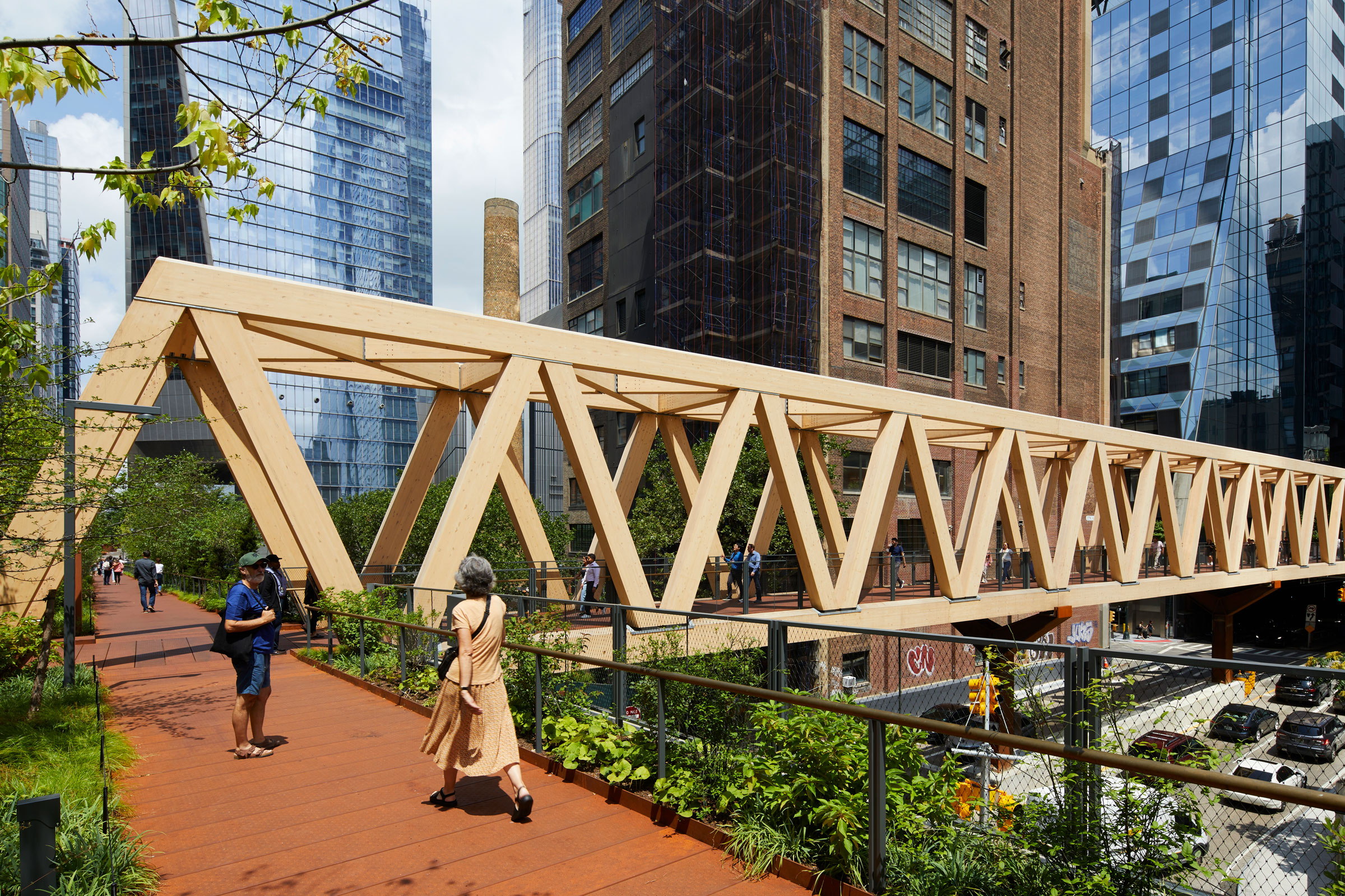
The High Line – Moynihan Connector is a pair of bridges designed by SOM and Field Operations. Photo by Lucas Blair Simpson
Located on a former New York Central Railroad spur, the High Line is a 1.45-mile-long elevated greenway that runs from Manhattan’s Gansevoort Street to 34th Street on Manhattan’s West Side. The greenway is owned by the City of New York and is operated and maintained by Friends of the High Line—a nonprofit conservancy—in collaboration with the NYC Department of Parks & Recreation.
The High Line was constructed in three stages, with individual sections opening to the public in 2009, 2011, and 2014; notable spots along the greenway include the Tiffany & Co. Foundation Overlook, 14th Street Passage—a semi-enclosed passageway that shows art, history, and curated videos every evening at dusk—and the 22nd Street Seating Steps, a popular picnic area that hosts site-specific art installations.
In June 2019 the last section of the original rail structure opened as the Spur—a public space with food, restrooms, access points, art, and program areas. This was followed in 2023 by the opening of the High Line – Moynihan Connector, a pair of bridges designed by Skidmore, Owings, and Merrill (SOM) and Field Operations, that allow pedestrians to access transit amenities with only one street crossing.
From the beginning preserving and maintaining the site’s biodiversity was central to the Friends of the High Line’s vision for the greenway. Its many distinct garden zones—designed by Dutch planting designer Piet Oudolf—are inspired by the wild, self-seeded ecosystems that reclaimed the railway after the trains stopped running. Each garden was meticulously cultivated using a naturalistic approach, with Oudolf prioritizing the use of grasses, shrubs, and perennials to evoke native grassland ecologies; 500+ plant species were selected based on appearance across their entire life cycles, meaning the gardens remain beautiful and visually appealing across all four seasons even when not in bloom.
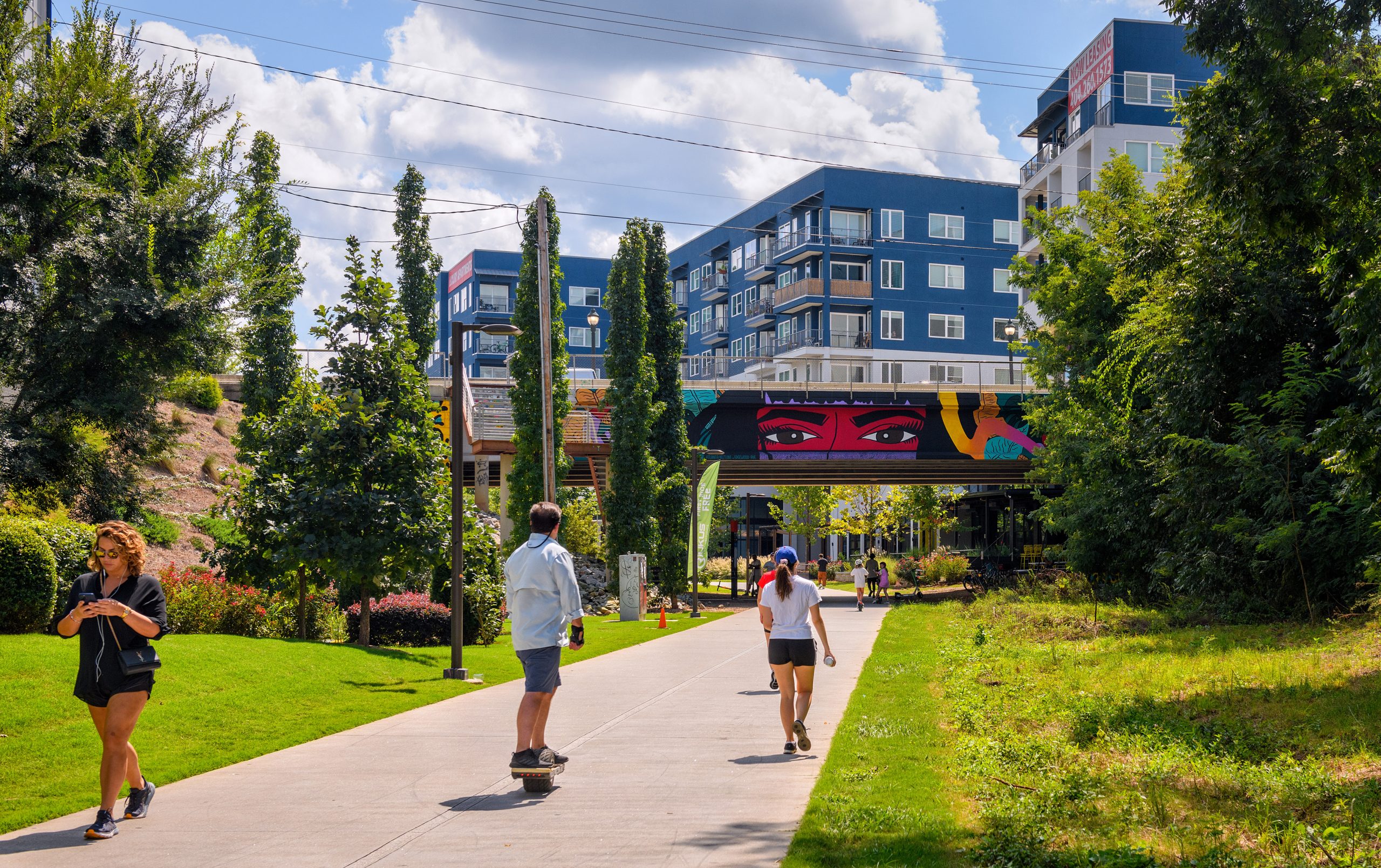
2. Atlanta Beltline, Atlanta
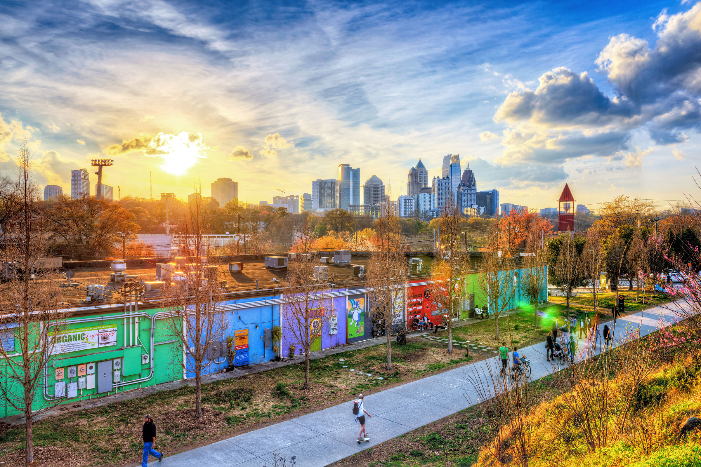
The Beltline in Atlanta connects neighborhoods and traverses parks, shopping, and more. Photo by Gene Phillips, courtesy of ACVB and AtlantaPhotos.com
Occupying a former railway corridor that encircles the city’s core, the Atlanta Beltline is a 22-mile multi-use greenway that weaves together a network of parks, trails, and public transit options. The first portion of the Beltline opened in 2008, and the greenway has continued to expand since, becoming a popular destination for walking, jogging, and cycling. As of April 2025 the Beltline encompassed 11 miles of completed trails along with 10 miles of connector trails that link the greenway to parks and other public amenities.
In addition to parks, the greenway is home to the Atlanta Beltline Arboretum, one of the region’s largest and most significant arboretums; designed in partnership with Trees Atlanta, the arboretum was purposefully cultivated to restore local ecosystems and features a variety of trees, woody plants, grasses, and wildflowers that help provide habitats for birds, butterflies, and pollinators.
The Beltline also hosts one of the largest public linear art exhibits in the Southeast United States. Sculptures and murals—both permanent and temporary—can be found along the greenway’s length, as can a revolving cast of performers, musicians, and other visual artists. It’s all part of what’s making Atlanta continue to be ranked as a top green city.
3. Dequindre Cut, Detroit
Running parallel to downtown Detroit’s St. Aubin Street and built along a former Grand Trunk Railroad line, the 2-mile Dequindre Cut is a predominately below-street level greenway that begins in the East Riverfront and spills out into the heart of Eastern Market. Opened in 2009, the Cut is currently managed by the Detroit Riverfront Conservancy and was developed in collaboration with the federal government, the City of Detroit, the Community Foundation of Southeast Michigan, and the Detroit Economic Growth Corporation.
The Dequindre Cut consists of a 20-foot-wide paved pathway—complete with dedicated pedestrian and bike traffic lanes—and is home to colorful graffiti and urban artwork throughout. Visitors can access the greenway from any one of the many entrance ramps located along its length.
A half-mile extension to the Cut opened in 2016; the new section runs from Gratiot Avenue to Mack Avenue and includes the Wilkins Street Plaza, an outdoor shelter featuring bike racks and numerous seating options.
4. Waterloo Greenway, Austin
Planned and developed by the Waterloo Greenway Conservancy in collaboration with the City of Austin, the Waterloo Greenway is a 1.5-mile linear park system that, when finished, will encompass 35 acres of interconnected green space.
As of April 2025 the Waterloo Greenway’s first phase was the only portion open to the public. This section includes the combined Waterloo Park—home to trails, gardens, an elevated skywalk, and playscapes—and world-class Moody Amphitheater, as well as Symphony Square, a community gathering space whose 350-seat open-air amphitheater hosts a revolving calendar of free park events, programs, and festivals throughout the year.
The second phase includes construction of The Confluence and Palm Park, with the former slated for completion in 2026 and the latter targeting completion by the end of 2028. The Confluence is set to occupy the ecologically diverse landscape where Waller Creek meets Lady Bird Lake and will contain three lightweight suspension bridges, offering pedestrians a birds-eye view of the restored delta habitat. Palm Park will introduce several new amenities focused on family gatherings and kid-friendly play areas.
The greenway’s third phase is expected to connect the previous phases to create a continuous path from 15th Street to Lady Bird Lake. Though still in the schematic and concept-design stages, tentative plans center around the Refuge, a creek-level exploration zone that aims to connect community members—and children in particular—to meaningful ecological experiences both in and around the water.
5. Neuse River Trail, Wake-Johnston Counties, NC
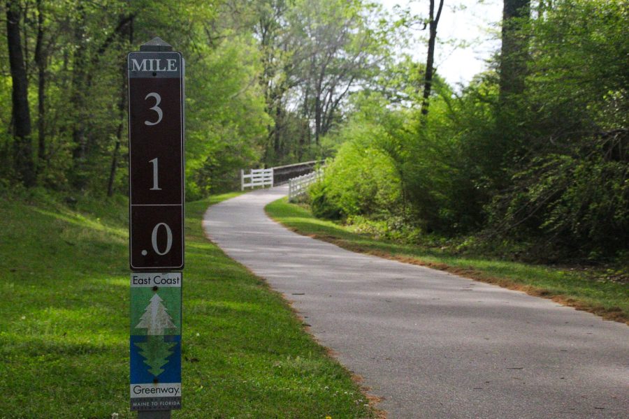
The Neuse River Trail is a series of connected greenways spanning 34.6 miles of riverine habitat in North Carolina and runs all the way from Raleigh to Clayton. The trail is also part of both the East Coast Greenway and Mountain-to-Sea Trail. Photo by Andrew Biro
Beginning at Falls Lake Dam in north Raleigh, the Neuse River Trail—which is really a series of connected greenways—is a paved recreational pedestrian trail that meanders along the banks of the Neuse River and offers ample opportunities for kayaking, canoeing, fishing, hiking, and cycling.
Spanning approximately 34.6 miles, the Neuse River Trail retains this name for the majority of its length until it crosses the Wake County/Johnston County border, at which point it becomes the 4-mile Clayton River Walk on the Neuse before terminating in the 1.5-mile Sam’s Branch Greenway.
Historic markers and interpretive signage detailing the Neuse’s diverse wildlife can be found along the greenway, while several suspension bridges provide breathtaking views of the river itself; an outdoor art exhibit consisting of painted wooden butterflies can be seen while traversing the Sam’s Branch Greenway portion of the trail.
The Neuse River Trail is also part of both the East Coast Greenway—a 3,000-mile pedestrian trail that runs from Florida to Maine—and the Mountain-to-Sea Trail, North Carolina’s 1,175-mile state hiking trail connecting the Great Smoky Mountains to the Outer Banks.
6. Katy Trail, Dallas
The Katy Trail in Texas is a historic greenway built on an abandoned section of the old Missouri-Texas-Kansas Railroad—colloquially known as the MKT, K-T, and eventually, “Katy” railway—that runs through Dallas’ Uptown and Oak Lawn neighborhoods.
Construction of the greenway began in 2000 following the founding of Friends of the Katy Trail—a nonprofit dedicated to maintaining, enhancing, and advocating for the Katy Trail as Dallas’ premier recreational trail. The greenway was designed in collaboration with the SWA Group—an international landscape architecture, planning, and urban design firm—and is dominated by native plantings and vegetation.
Today Katy Trail is largely complete and consists of both a 3.1-mile soft-surface pedestrian path for walkers and runners as well as a 3.5-mile shared concrete path for bikes and other wheeled transport; a revolving gallery of locally made sculptures and other artistic pieces can also be found on and around the trail. The greenway may be accessed from various entry points along its length and provides direct linkages to the Stemmons, Reverchon, Lee, and Dean parks.
7. Elliott Bay Trail, Seattle
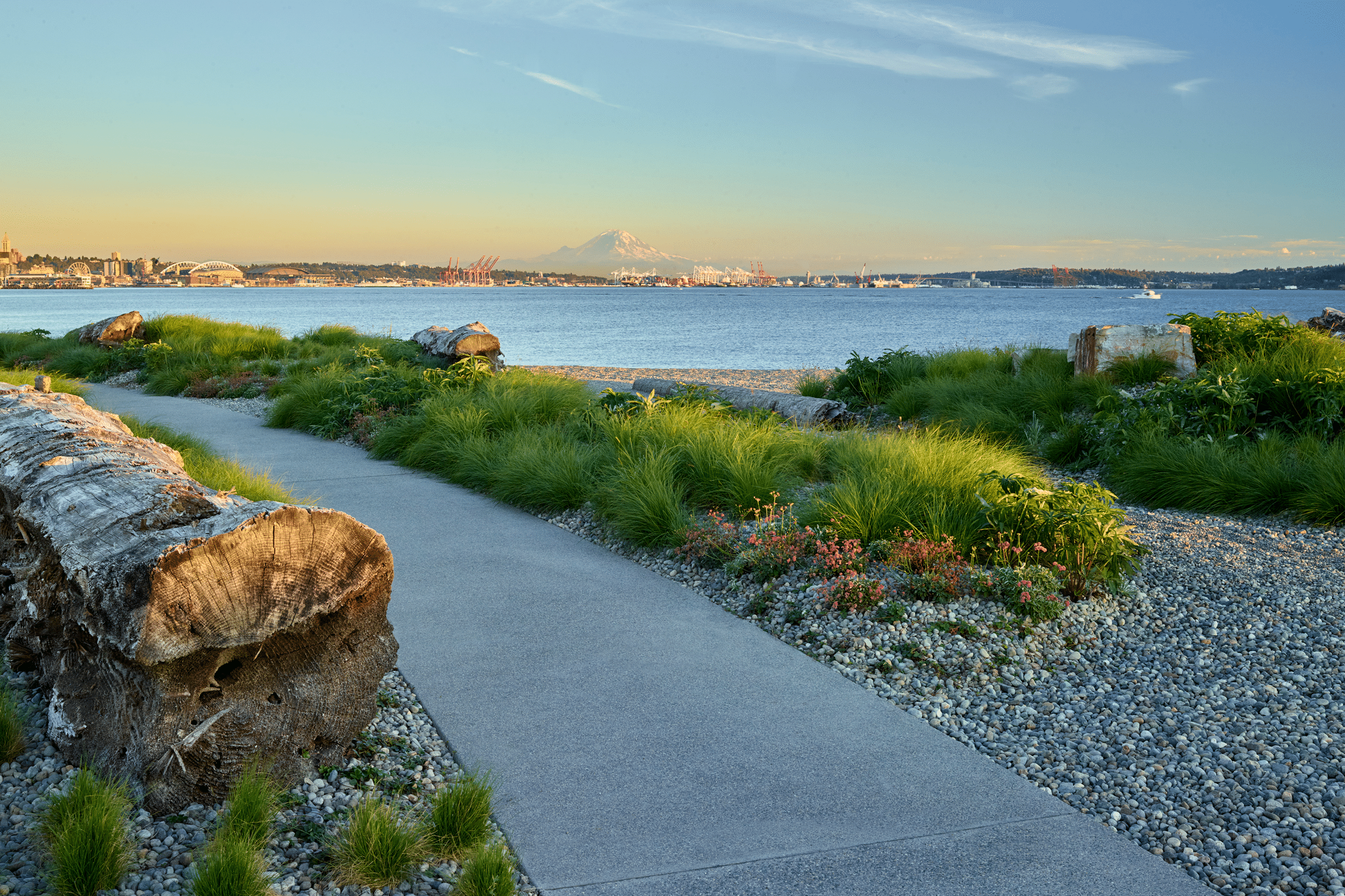
The Beach project redesigned pedestrian and bicycle paths to improve safety and upgrade the existing Elliott Bay Trail. Photo by Marion Brenner
Winding along the coast of picturesque Elliott Bay, the Elliott Bay Trail is an approximately 5-mile greenway that provides pedestrians with stellar views of the Puget Sound and offers numerous connections to north downtown Seattle.
The trail—which consists of a shared walking/bicycle path that eventually splits into two separate paths—runs through both Myrtle Edwards Park and the Olympic Sculpture Park, a 9-acre outdoor sculpture garden and public park operated by the Seattle Art Museum. A portion of the trail was redeveloped and expanded in 2019 as part of Surfacedesign’s redesign of The Beach, a 2.6 acre section of waterfront owned by the Expedia Group.
“Before this project was completed the site’s shared bicycle and pedestrian path had a blind turn that was often submerged during storm events, making cycling or walking along the path dangerous,” Michal Kapitulnik, partner at Surfacedesign, wrote in a previous gb&d article. “This new portion of the Elliott Bay Trail separates and expands both a bike and pedestrian path.”