
How one interdisciplinary planning and design firm is reinventing the future of sustainable infrastructure.
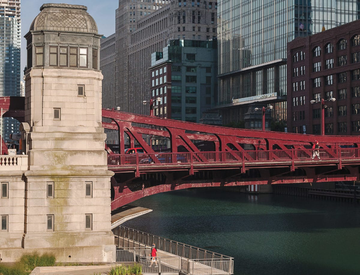
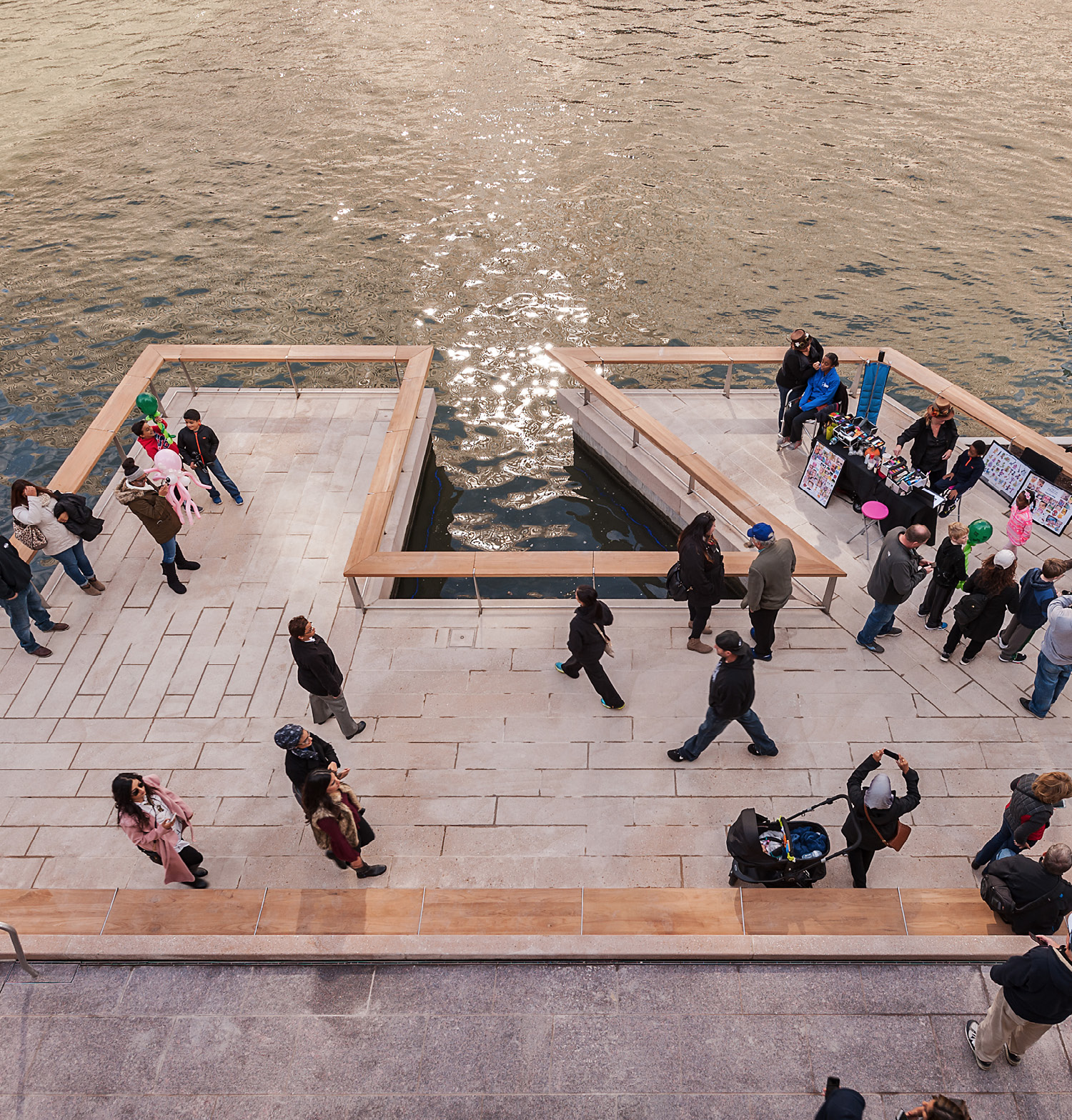
Sasaki’s focus on resiliency transforms projects like the Chicago Riverwalk. [Photo: Christian Phillips Photography]
By the end of 2017’s hurricane season, it was clear to communities across the United States that our understanding of nature’s fury and the metrics by which we measure human safety are quickly shifting.
When 100-year floods happen every 10 years, or 500-year storms happen multiple times in one lifetime, it’s obvious that communities need to do more than just armor themselves: They must adapt. Infrastructure must protect, and to do that, it must flex. Above all, it needs to nurture future growth. At Boston-headquartered global design firm Sasaki, this has been obvious for nearly a decade.
“Resiliency,” says Brie Hensold, urban planner and principal at Sasaki, “is really the ability of a place or community to respond to whatever is thrown at it and to bounce back stronger. It’s the ability to recover and achieve a new level of operating that is stronger than before.”
[Photo: Courtesy of Sasaki]
Sasaki in Action
It’s hard to imagine bouncing back, stronger than ever, after storms wipe out entire towns. In 2008, flooding in Cedar Rapids forced thousands to flee and caused more than $6 billion in damage. Ten square miles were inundated, devastating homes and cultural icons. And yet, just months later, Cedar Rapids was ready to begin rebuilding.
Community leaders called in Sasaki to lead flood recovery efforts as well as planning for future flood infrastructure around areas most likely to see future inundations. The process began and finished with community engagement. “We started out proposing a range of options to help residents understand what was possible,” says Laura Marett, a senior landscape architect whose first day at Sasaki had her boarding a plane to Cedar Rapids.
One of those options was to build a series of walls that disconnected the community from the river but that would allow homes to be rebuilt in place. A second was to retreat from the floodplain and turn those areas into a riverfront park. “I was very surprised the community landed on a floodplain park that gave the river room for future flooding,” Marett says. “They wanted not to turn away from the water, but instead to use it as part of the community.”
Throughout the Cedar Rapids project design, the community and Sasaki landed on a flood-wall-cum-amphitheater as well as revised evacuation planning, interim flood protection, improved warning systems, and larger civic initiatives addressing watershed issues.
Sasaki assists clients with everything from watershed planning to grant-writing to designing built environments for greater resiliency. [Photo: Edward Caruso]
The Big Picture
Of course, to do any of this requires a deep understanding of ecological systems, human systems, and the ways the two interact. It also requires planners and designers to change their own thinking. Sasaki staff describe the rebuilding after 2012’s Hurricane Sandy as a critical turning point in which the firm’s approach—already staffed by a multi-disciplinary team of architects, designers, and engineers—pivoted to a new concept of design and planning. Individually, as one team member put it, changes in thinking continue to arrive as natural progressions.
“It’s a longer term appreciation for the benefits of looking holistically at a project,” says Victor Vizgaitis, principal and chair of Sasaki’s Urban Studio. “At Sasaki, we are having conversations that constantly take you from a focused consideration of how a building might operate or function on its own right to how it might operate on a community scale, how it would impact stormwater flow, energy use, cars and pedestrian access, safety measures, sustainability measures, and day-to-day occupancy.”
It’s a widening of scope that allows communities to build smarter.
[Photo: Christian Phillips Photography]
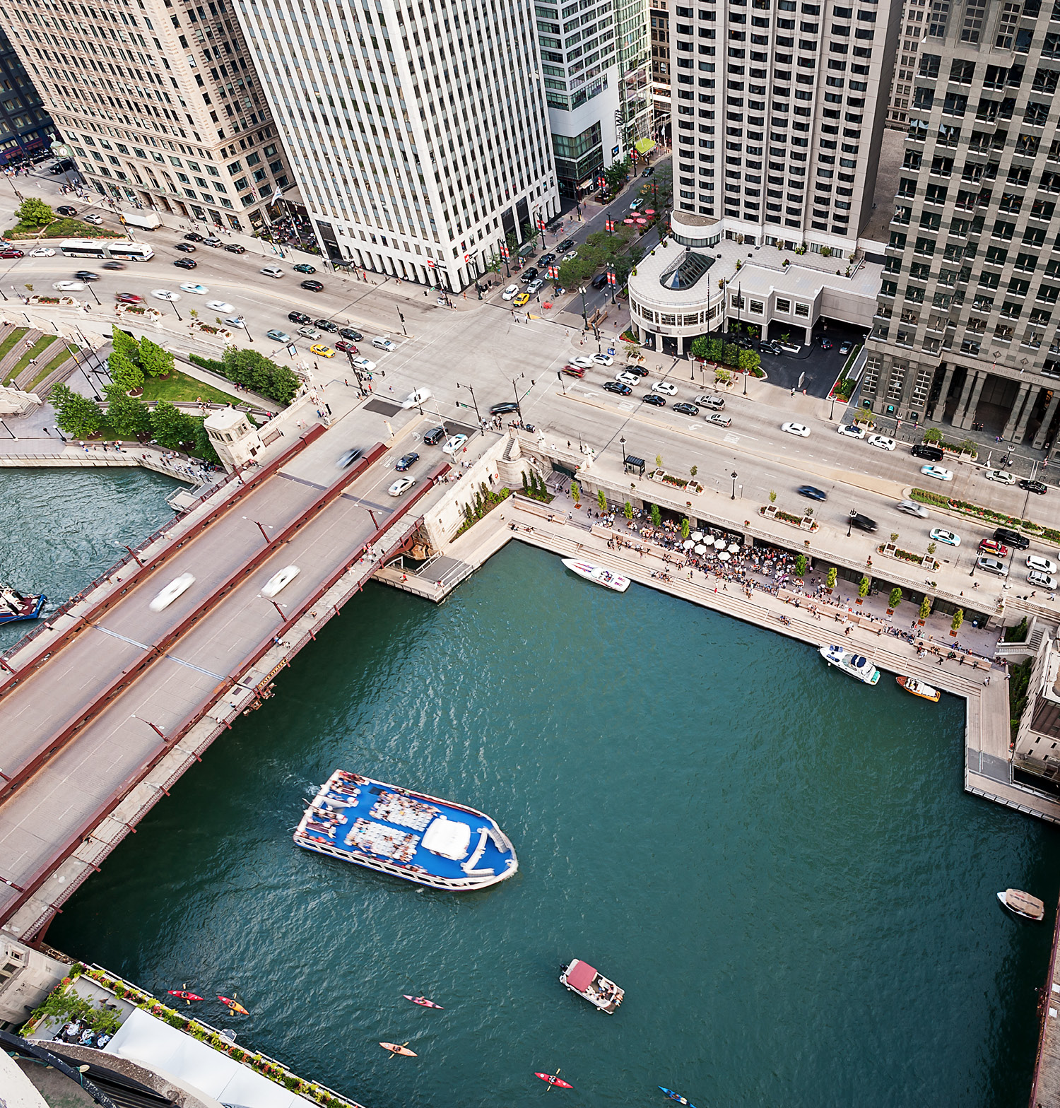
Transforming the Chicago Riverwalk
Chicago’s river is as famous as the city itself, thanks to historic engineering that reversed the waterway’s flow and its integration with the industries that built the Second City. But despite its deep connection to Chicago and its people, the river remained, in many ways, separate. Over the last decade, the city has worked to reconnect its people with its aquatic artery via the Chicago Riverwalk project. Sasaki came onto the initiative in 2009, tasked with transforming six blocks of riverfront into a community gathering space.
The design team was dictated by requirements including a 25-foot build-out limit to navigate under bridge connections and pedestrian activities. This was complicated by annual flood dynamics that threaten any permanent infrastructure on the site. “We had a robust framework of desires and wishes for the space,” says Gina Ford, Sasaki principal and landscape architect. “We were nestled into a broader, longer conversation about the river that we had learned from.”
But Sasaki has been doing waterfront projects for decades, and early into the riverwalk design, the team established four major pillars for their design: economic, recreational, cultural, and environmental. “It’s an expansion of the triple bottom line used in sustainability measures,” Ford says. Resiliency, after all, is about more than environmental standards. It’s about people and communities, too.
[Photo: Christian Phillips Photography]
A Multi-Layered Approach to Resiliency
Each of the Chicago project’s four interests regularly compete, but the design team found balance through its use of materials. “There’s an elevation to which, based on historical data, we knew the river would rise, and everything below that elevation would be under water,” says Zach Chrisco, a Sasaki principal and civil engineer who worked on the project. “Critical infrastructure, pedestrian walkways, electrical, all of it could be submerged.” For these spaces, the team sourced electrical components rated for occasional flooding, land-scaped with plants that can be submerged without drowning, and used construction materials that can be flooded without holding on to water or debris.
Within its opening week, the Chicago Riverwalk flooded and a mini media panic ensued. Yet, “12 hours after that first flood receding, the city had cleaned it off,” Chrisco says. The walk was open again for business.
This sort of flexible thinking and multi-layered approach to resiliency has earned the Sasaki team numerous awards. One of the firm’s proudest achievements can be found closer to its home base in Fall River, Massachusetts, where Sasaki designed the first lab science zero net energy building in the northeastern United States. The Bristol Community College Health and Science Building is a 2017 AIA COTE winner and, perhaps more importantly, a true community effort. Like the riverwalk, this project wasn’t just about the construction itself, but its connection to the landscape.
[Photo: Edward Caruso]
Planning For the Future
Sasaki’s designers, architects, and engineers use their multidisciplinary, systems-based approach in more than just client projects. Team members teach seminars and classes, training the next generation of planners from top design and engineering schools like MIT and Harvard. Sasaki’s young professionals often enter the firm as talented interns and return after graduation as staff. Moreover, interns and staff regularly go back into their communities to encourage community education and participation around resiliency issues like climate change.
Jill Allen Dixon, now a senior associate and planner at Sasaki, started at the firm in 2009 as an intern. In 2014, she and other team members were working on a research project examining sea level rise in Boston, and in 2016, she continued to shape Boston’s long-term resiliency to climate change impacts through Climate Ready Boston. “There is a lot of complex scientific information out there, and it’s important for us to help translate that to the public,” she says.
Data translation and illustration is a large part of the community education process, which is integral to all future resiliency planning efforts, Vizgaitis says. “A lot of the conversations around climate change and sea level rise are abstract. Our Sea Change research project was a good eye-opener for a lot of people to push denial aside because the maps tell all. It’s maps and mapping—no opinions anymore.” The project included a curated showcase highlighting Boston’s vulnerabilities and demonstrating options for design solutions. It won a 2016 ASLA Communications Honor Award for its ability to connect with all kinds of audiences.
A push toward change and a future based on resiliency comes, Vizgaitis says, when disciplines join together to help the public understand what’s at stake and speak out for public action. “That’s when people have to start to pay attention.”
Read more about Sasaki.